Accurate address resolution is critical for location-based services in today’s digital world. For delivery fleets, navigation apps, and real estate platforms, reliably converting coordinates into human-readable addresses is essential for efficiency and user experience. This article will cover the intricacies of using a maps API get address from coordinates.
Leveraging Maps APIs for Reverse Geocoding
The success of location-based services hinges on the performance and reliability of reverse geocoding APIs. These powerful tools offer the ability to transform geographic coordinates into detailed address information, empowering developers to create innovative location-driven applications.
Exploring the Top Reverse Geocoding APIs
When it comes to selecting the optimal maps API for your reverse geocoding needs, there are several leading options to consider. Each platform offers unique strengths, catering to the diverse requirements of modern businesses and developers.
Google Maps Geocoding API
As a market leader, the Google Maps Geocoding API is renowned for its global coverage and meticulous address data. Developers often gravitate towards this solution for its unparalleled accuracy, making it a preferred choice for mission-critical applications.
Strengths:
- Accuracy: Google’s extensive data sources and advanced algorithms deliver pinpoint precision in address resolution.
- Comprehensive Documentation: The API’s developer-centric documentation and resources provide a seamless integration experience.
Considerations:
- Pricing: Google’s usage-based pricing model can become costly, especially for high-volume projects.
- Usage Limits: The API imposes strict quotas on the number of requests per day, which may constrain larger-scale deployments.
Example Code (JavaScript):
const latitude = 40.712776;
const longitude = -74.005974;
const apiKey = 'YOUR_GOOGLE_API_KEY';

const googleGeocodingUrl = `https://maps.googleapis.com/maps/api/geocode/json?latlng=${latitude},${longitude}&key=${apiKey}`;

fetch(googleGeocodingUrl)
  .then(response => response.json())
  .then(data => {
    console.log(data.results[0].formatted_address);
  })
  .catch(error => {
    console.error(error);
  });
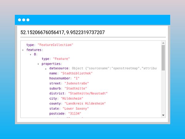
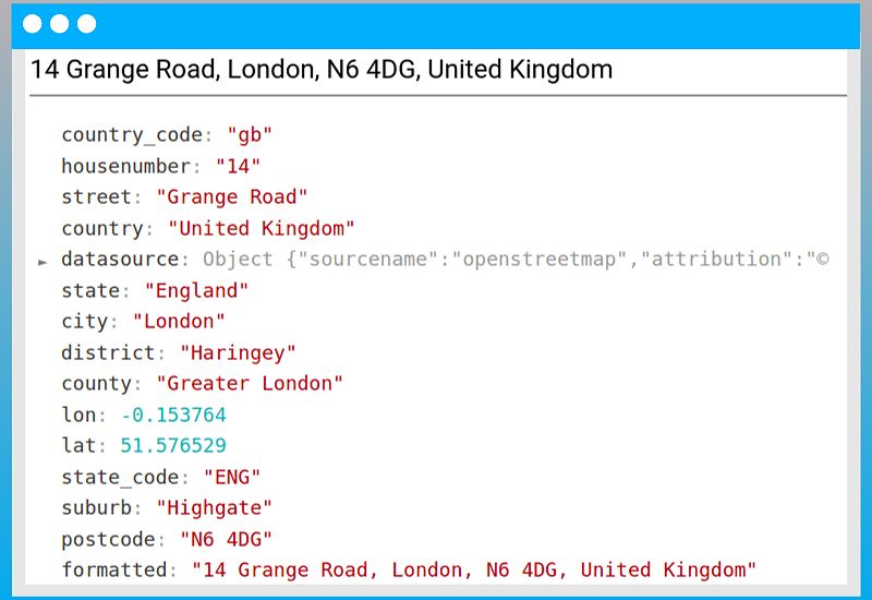
Geoapify API
Geoapify offers a cost-effective and developer-friendly alternative to the Google Maps Geocoding API. Leveraging open-source data from projects like OpenStreetMap, Geoapify provides a robust reverse geocoding solution with a generous free tier.
Key Features:
- Open Data: Geoapify’s foundation on open-source mapping data promotes transparency and customization.
- Affordability: The platform’s free tier allows up to 3,000 requests per day, making it an attractive option for budget-conscious projects.
Example Code (Python):
import requests

latitude = 52.534708
longitude = 13.403800
api_key = 'YOUR_GEOAPIFY_API_KEY'

geoapify_url = f'https://api.geoapify.com/v1/geocode/reverse?lat={latitude}&lon={longitude}&apiKey={api_key}'

response = requests.get(geoapify_url)
data = response.json()
print(data['features'][0]['properties']['formatted']);
Mapbox Geocoding API
Mapbox’s geocoding API stands out for its precision and advanced features tailored for developers. Those already embedded in the Mapbox ecosystem often find this solution to be a natural choice for their reverse geocoding needs.
Strengths:
- Precision: Mapbox is renowned for delivering highly accurate geocoding results, thanks to its extensive data sources and algorithms.
- Developer Tools: The platform offers a suite of developer-centric features, such as batch processing and advanced customization options.
Pricing Considerations:
While Mapbox’s pricing may be higher than Geoapify’s, many developers find the investment worthwhile for the enhanced features and performance.
Example Code (JavaScript):
const mapboxAccessToken = 'YOUR_MAPBOX_ACCESS_TOKEN';
const latitude = 37.774929;
const longitude = -122.419418;

const mapboxGeocodingUrl = `https://api.mapbox.com/geocoding/v5/mapbox.places/${longitude},${latitude}.json?access_token=${mapboxAccessToken}`;

fetch(mapboxGeocodingUrl)
  .then(response => response.json())
  .then(data => {
    console.log(data.features[0].place_name);
  })
  .catch(error => {
    console.error(error);
  });
Understanding API Pricing Models
When evaluating reverse geocoding APIs, it’s crucial to understand the various pricing structures. While some providers offer usage-based pricing, others may have tiered plans or fixed monthly fees. Carefully reviewing the pricing details and volume thresholds can help you select the most cost-effective solution for your project’s needs.
Factors Affecting Geocoding Accuracy
Reverse geocoding accuracy can vary depending on several factors, including:
- Population Density: Addresses in densely populated urban areas tend to have higher accuracy compared to sparsely populated rural regions.
- Data Freshness: APIs relying on more up-to-date address data will generally provide more accurate results.
- Address Type: Street addresses are typically more precise than PO Boxes or other non-standard address formats.
Understanding these accuracy considerations can help you set appropriate expectations and make informed decisions when selecting a reverse geocoding API.
Integrating Reverse Geocoding into Your Application
Seamlessly integrating reverse geocoding into your application involves several key steps, from obtaining API credentials to implementing error handling strategies.
API Key Acquisition and Authentication
The first step in leveraging a reverse geocoding API is acquiring a unique API key. This key serves as the authentication mechanism for your application, granting access to the provider’s services. The process typically involves creating an account, generating the API key, and securely integrating it into your codebase.
Making API Requests
With your API key in hand, you can begin crafting HTTP GET requests to the reverse geocoding API endpoint. This involves passing the necessary parameters, such as latitude and longitude, to retrieve the corresponding address information.
Error Handling and Optimization
Building a robust reverse geocoding system requires effective error handling and performance optimization. Strategies like retry logic, rate limit management, and asynchronous request processing can help ensure your application remains responsive and reliable even during periods of high demand.
Caching and Batch Geocoding
To further enhance the performance of your reverse geocoding implementation, consider incorporating caching techniques to store frequently accessed addresses. Additionally, leveraging batch geocoding capabilities can significantly improve efficiency when processing large datasets.
Advanced Techniques and Considerations
As you master the fundamentals of reverse geocoding, exploring advanced techniques can unlock even greater value for your location-based applications.
Handling Ambiguous Addresses
Not all address data is unambiguous. Developing strategies to manage incomplete, inconsistent, or conflicting address information can help provide users with the most appropriate and useful responses.
Address Enrichment
Combining reverse geocoding results with additional data sources, such as points of interest or demographic information, can enhance the user experience by providing richer context and insights.
Privacy and Data Security
In an era of heightened data privacy concerns, it’s essential to consider the implications of reverse geocoding and implement measures to protect user privacy. Leveraging features like data anonymization and aggregation can help ensure compliance with regulations like GDPR and CCPA.
FAQ
1. What is reverse geocoding?
Reverse geocoding is the process of converting geographic coordinates (latitude and longitude) into a human-readable address.
2. How do I choose the right reverse geocoding API?
Consider factors such as accuracy, pricing, data sources, and documentation when selecting a reverse geocoding API. Evaluate your project’s specific needs to make the best choice.
3. Are there free reverse geocoding APIs available?
Yes, several APIs offer free tiers, such as Geoapify, which allows up to 3,000 requests per day. However, be aware of the limitations and pricing for higher usage.
4. How can I improve the accuracy of reverse geocoding?
Ensure that you are using an API that has up-to-date data and consider factors like population density and address type, which can affect accuracy.
Conclusion
Mastering reverse geocoding is a crucial step in creating exceptional location-based services. By understanding the strengths and nuances of leading maps APIs, developers can select the optimal solution to power their applications. Implementing robust error handling, caching strategies, and advanced techniques further solidifies the reliability and performance of reverse geocoding systems.
As the demand for precise location data continues to grow, embracing the power of reverse geocoding will allow you to develop innovative, user-centric experiences that set your applications apart in the ever-evolving digital landscape.